Image:
Credit: Ordnance Survey
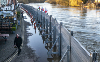
New dataset could help monitor and manage worsening coastal erosion and flood risks across the UK
The Ordnance Survey (OS) has launched a new dataset on tidelines around Great Britain's coast to help support the management of erosion, flood risk, and worsening climate impacts. The OS announced...
To continue reading this article...
Join BusinessGreen
In just a few clicks you can start your free BusinessGreen Lite membership for 12 months, providing you access to:
- Three complimentary articles per month covering the latest real-time news, analysis, and opinion from Europe’s leading source of information on the Green economy and business
- Receive important and breaking news stories via our daily news alert
- Our weekly newsletter with the best of the week’s green business news and analysis