Team behind Project Vulcan emissions map set out ambitions for new tool for business execs that could hook up with Google Earth and provide 3D emissions data at a building by building level
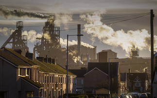
A NASA-sponsored research programme has produce the most accurate picture to date of the US's carbon emissions, and hopes to produce future versions that could prove invaluable to businesses and policymakers.
Project leader Kevin Robert Gurney said that the project, known as Project Vulcan, was originally designed to help identify the "missing sink" – a large amount of carbon that goes into the biosphere every year that is currently not well understood by climate scientists.
"For 20 years we'd been using a map that wasn't good enough for what we were trying to do," he said. "It was very coarse [and just] wasn't accurate enough."
The project, which also received funding from the DoE, took publicly accessible air pollution data from the Environmental Protection Agency, extrapolated it to estimate greenhouse gas emissions, and mapped it to a grid across the US to a resolution of 10km.
It mapped carbon emissions across the US and has presented the data in a video mapping US emissions levels over time.
The project attracted attention from US policymakers, and Gurney is hoping that the results will help attract funding for two other projects; an expansion of Vulcan's research into Mexico and Canada, and Hestia, an initiative which will map carbon emissions at a building by building level, in 3D.
That project would probably be made available as an overlay in Google's popular Google Earth software, Gurney said.
Vulcan was designed for scientists, he said, adding that Hestia would go further and could prove a valuable tool to business executives and public policymakers. "If we really want to do something that meets scientific goals but could also be useful for industry, for the public, policy makers and commerce, then we want to do something that relates to people's lives," he said. "It needs to be a photorealistic landscape, and look like the real world."
Hestia will be piloted in Indianapolis before hopefully extending elsewhere, including into the developing world, where the project would make use of satellite data, he concluded.